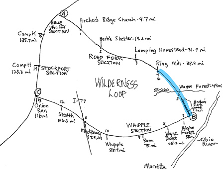
Part 1, Part 2, Part 3, Part 5, Part 6, Part 7
April 12, 2015
A Nineteen-Mile Test of My Hiking Legs
The sky over Ring Mill the night before had been crystal clear, great for watching the space shuttle make its way across the vast, starry expanse. But that same clear sky had also drawn the coveted warm air upward, causing us to spend an uncomfortably cold night.
Just after sunrise we layered up and ate breakfast in the shelter, grateful for the roof that separated us from a thick layer of frost. Steaming coffee tasted particularly good in the frigid air. My supply was low and our resupply vehicle was still two days and 18.5 difficult miles away. I tend to savor things much more when I know the quantity is limited.
We began the day’s ten-mile journey hiking along the Little Muskingum again, this time on the opposite side. We hoped to see the turkeys that we’d stirred up the day before. The trail led through some tall grass, but it was still well blazed and easy to follow.

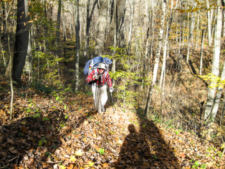
George inspects hiking pole
Sometime that morning, I discovered that I had lost the plastic lip from the bottom of one of my hiking sticks. Jim and George teamed up to fit a new one cut from the bottom of a five-gallon bucket we found along the way. As usual, Jim had the appropriate tools in his pack to do the job.
After a short stretch on the road, we entered into a deeper part of Wayne National Forest. The trail was well manicured and blazed. This didn’t happen by itself: it took hard work by the folks who had taken it upon themselves to maintain this piece of the trail. Because of them, I was able to spend more time soaking in the beauty of the surrounding landscape and less watching for blazes and obstructions.
Perhaps I should have been just a bit more focused on the path in front of me for at about the five-mile mark I suddenly fell forward with a bone-jolting thud. I didn’t even have time to get my hands in front of me. The good news was that when I stood back up I didn’t feel any worse than I did before I took the spill. The bad news was that I felt the same—tired, sore, and hungry. I started lobbying the guys for a lunch break. We found a suitable place within a mile. I was so hungry I didn’t cook. Tuna and dry ramen noodles might as well have been steak and spaghetti.
We still had at least four miles to go to reach SR 260 and our stash of water and canned food. We planned to camp just past that crossing. Before we had gone very far, both George and Jim joined the competition for the most violent fall of the day. Fortunately, they also rebounded well. We couldn’t resist scoring each other on a scale of 10, each of us receiving a well-deserved 9. I was careful not to have a repeat performance that day, even if it might have gotten me a perfect rating.
Jim navigates steep hill
Jim and I had hiked this stretch the year before. It was tough then, and it was tough now. In addition to the challenging terrain, the freezing temperature from that morning had risen 50 degrees to reach 82. Before day one, we had decided to enjoy the miles and not be rushed. Now for the first time this trip, I just wanted to get to camp. The last two miles seemed like five—and I wasn’t enjoying them so much.
We finally reached 260, grabbed the cans and water jugs we had hidden the week before, and continued about a quarter mile more to our preselected campsite. I was exhausted, but at the same time I felt blessed that I was able to make this trip. And I was hopeful that I might actually sleep that night.
Beans never tasted better. We didn’t build a fire since the evening was warm. We felt a little silly retiring at 8:30, but it had also been dark for a couple of hours already and we were beat. I heard no animal sounds that night, maybe because I slept like a rock until 3:30.
As I lay awake in the early morning in my small but adequate Coleman tent, I heard an occasional vehicle make its way along 260, most likely transporting folks to their places of work. That put the hike in perspective. Vigorous exercise, sure, but at my own pace and by my own choice. Nothing to stress about. I wasn’t even following the news. Who knew what could have been happening elsewhere while I was in my own forest habitat. I was sure Bonnie would let me know if anything catastrophic occurred.
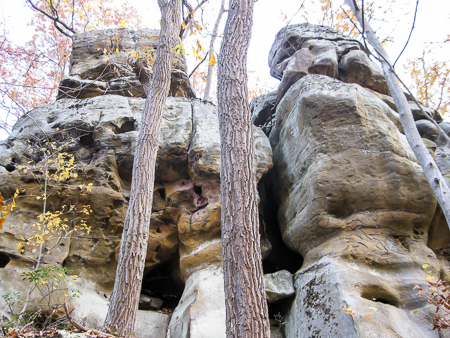
Rock formation along Archer’s Fork Loop Trail
Day six was another challenging one, but I had no complaints. We were treated to the beautiful cliffs and rock formations of Archer’s Fork. The Wilderness Loop follows about half of the Archer’s Fork Loop Trail. In my opinion, this five-mile stretch is the most scenic section of the Wilderness Loop, and one of the top five on the entire BT.
Around 3:30 we reached my car. We had conquered the first leg of the Wilderness Loop! I was relieved to find my car undisturbed. This seemed to be a decent spot to leave a vehicle, though if you do I would let the Washington County sheriff know why it is parked there. I appreciate the fact that while my Caravan is a workhorse, it is definitely no showpiece. Any would-be thieves or vandals who ran across it would probably just keep looking.
We jumped in the car and headed out. It felt strange to have four wheels under me again. I drove down the hill toward Route 7 and the Ohio River. Our plan was to stay the night at Leith Run Campground, part of the Wayne National Forest, with free camping like in Lamping Homestead and Ring Mill. That is, after a trip to Walmart. The skies looked like they were ready to let loose as we pulled into the parking lot. As we scurried inside, my eyes were drawn to a McDonald’s. Hmmm . . . a Big Mac and large fries just might be called for as I gathered my strength and readied myself for the second leg of the Wilderness Loop.
See additional photos from first leg (Road Fork section)
Finishing Road Fork section