Part 2, Part 3, Part 4, Part 5, Part 6, Part 7
February 2, 2015
Bonnie and I have been busy working on the marketing aspect of Hiking Without Dave, so I’ve had my latest hiking story on hold until now. It was the biggest backpacking trip I’ve ever taken, so big I’ve divided it into multiple chapters.
The Preparation
My hike had to be big. After all, it commenced on my wife’s birthday. I wouldn’t have missed her big day for something puny. Another reason I supersized it was that it would be taking the place of a thru-hike of the entire, 1,444-mile Buckeye Trail. After telling everyone I know (and even a few random strangers who seemed like they should hear) that I was planning to tackle that Magellan-like journey in 2015, I needed to give them at least something halfway decent after I fizzled out on the idea a few months back.
It wasn’t because I didn’t want to thru-hike the entire loop. I have ever since I finished my circuit hike in 2012. And 2015 would be the perfect year. When people asked “Why,” I told them that I wanted to do more that year than just start Medicare and Social Security. The problem came when people got to the next question, “How”:
How will you get five months free to hike?
How will Bonnie and Dad get by all that time?
How will you work out all the overnight camping logistics?
How could a grown man pull a stunt like this?
One night as I wrestled with these questions, an idea for a face-saving hike came to me in a dream. It would be on the Wilderness Loop in southeastern Ohio. It is still part of the Buckeye Trail, but essentially a one-tenth scale model of it. It was added to the large loop in 2005. I know from my circuit-hike experience that it is one of the most backpacker-friendly parts of the BT. And it is in one of the most beautiful and remote parts of Ohio.
I was amazed that Jim Gilkey and George Tyo agreed so quickly to go with me. They are great people to hike with. I had this big sales speech I didn’t get to deliver. Maybe they knew and just wanted to avoid it.
We decided to give ourselves 17 days: one for stashing, a zero day in the middle to shuttle a vehicle and nurse any wounds, and 15 days to average nearly ten miles each. We pored over the section maps to find the right places to camp. It became evident that a scouting trip would be necessary for the middle leg of the journey. A couple weeks before our hike, George and I headed over to the Marietta area.
After a night of camping at Wolf Run in Belle Valley, we headed down Interstate 77 for a breakfast at Lori’s in Caldwell, and then on to Macksburg. This was one of three places where we would have to rustle up a place to camp. One thing we wouldn’t have to rustle up would be anything from our food bags because D & E Restaurant was right there along I-77. We found someone in Macksburg who would try to work out a place for us to pitch our tents. He was country friendly and promised to call me back later that week when he had found a spot. One down.
Next we drove about 10 miles southeast to the tiny burg of Whipple. Once again we found kind people, one family willing to let us camp in their back yard. We even received an offer from the folks at the community store to have some chili ready when we hiked through. Another one down. Things were going great.
We backtracked through Macksburg for the final and tallest hurdle: finding a place to camp along the 20-mile stretch from there to Onion Run. As we drove the isolated back roads, we looked for a woodsy area in which we could stealth camp. The first prospect was a small family cemetery surrounded by a tall wrought iron fence. However, a sign warned us that the gate would close at night. We couldn’t imagine who would bother to come out to this no-man’s-land to lock us in with the other residents, but we decided to keep searching. This was a few miles shy of the 10-mile mark anyway.
We encountered fewer houses and more No Trespassing signs. Many of the signs were attached to others that proclaimed this to be a Licensed Shooting Area. We had heard earlier that this was coal company land, and some was leased to hunting clubs. We finally found a camping site at roughly the halfway point. (I can’t disclose exactly where it was, or it wouldn’t be stealth camping.) It was a beautiful pine grove with a deep bed of fragrant needles. We decided we probably shouldn’t tell the wives about this particular camping spot with the “special” signs, but Bonnie asks a lot of questions. It took quite a while to explain our decision. Even when she read this blog months later, she was still asking questions.
With our last camping problem tackled, we drove home to finish getting ready for the hike. I didn’t want to miss voting in the mid-terms, so I voted early on October 15. I asked the lady taking my information what would happen if I failed to complete the hike and returned home early. She said “If you do, just don’t let me catch you trying to vote again.” I hoped that voting twice wouldn’t even be a temptation. I should still be on the trail on November 4. However, I was still struggling with some doubt. My longest hike up to this point had been 56 miles five years ago in the same general area of the state, with some very ugly blisters to show for it. I held to the hope that older feet are tougher feet. In a week I would find out.
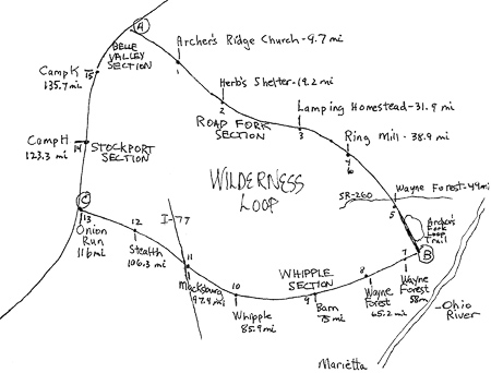
Wilderness Loop Map
After reading and enjoying your book, I really look forward to your adventures on the trail. This part one has me wanting the rest of the story as Paul Harvey might say. I really like the maps and the pictures also. I am learning more about Ohio and its geography and it is fun. Keep the stories coming. Ted
Thanks TW. Hope the three old guys make it far enough for there to be a “rest of the story.” CW