
by guest blogger Bonnie Spencer
November 7, 2015
Day 9: Island MetroPark to Canal Lock Park in Tipp City (16.1 trail miles)
It had been a week since our last hike and we were ready to get back on the trail. We would have a long day, not only from the trail mileage but also due to extra shuttling. Our plan was to break the hike into two segments. One reason was so that CW wouldn’t have to drive out of Dayton at the end of the day in rush-hour traffic. The other reason was weather-related. There was a possibility of heavy rain in the afternoon due to Hurricane Patricia. Our two-segment plan would give us the option to stop after lunch if we needed to. We also decided to hike backwards (counterclockwise). This was to avoid me having to drive a car out of Dayton, which I would have to do if we ended up with two cars at Island MetroPark. The logistics of shuttling cars is rather mind-boggling.
We reached Island MetroPark at 8:40 and found the gate closed. A park worker picking up trash said the park wasn’t open yet, so we drove a block down the street and got permission to leave a car in the lot of a social services agency. We then drove north to Taylorsville MetroPark and began walking back to the other car about 9:20. The day’s hike would be entirely on the Great Miami River Recreation Trail (GMRRT).
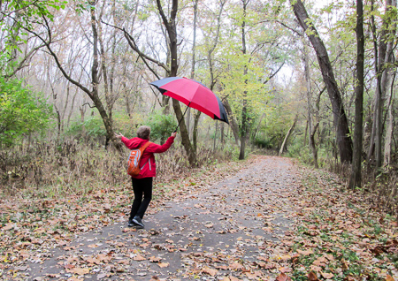
Dancing in the rain
The morning was cool and slightly windy. We were dry for the first 40 minutes. Then it became drizzly and our umbrellas went up. We kept up a good pace to get as much done as we could before heavier rains came. It was very pleasant. We thoroughly enjoyed the fall scenery and the light pattering over our heads. The bad thing was that, because of the rain, I couldn’t wear my sandals. My toes had to suffer inside hiking boots. But I still couldn’t resist dancing in the refreshing rain.
We completed the nine miles back to the car in three hours, then drove up to Tipp City to the northernmost point of the day’s hike. We had a delicious lunch at Sam and Ethel’s. When we came out of the restaurant, it felt colder and was still drizzling. Since we were mentally prepared to do some hiking that day in heavier rain and it hadn’t arrived yet, we parked the car at Canal Lock Park and got started on our second segment at 2:00.
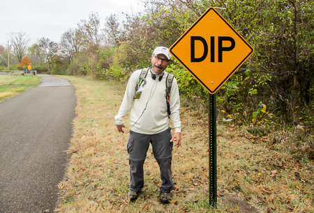
CW keeps me entertained
Before lunch my right hip had begun to hurt a little. I had taken an Ibuprofen, hoping that by the time we started out again the pain would be gone. That didn’t happen. Throughout the afternoon, the pain became progressively worse. I got slower and slower. By the time we reached the car at 4:40, I could hardly walk. My umbrella had become my cane since the drizzle had turned to barely a mist. The good thing, though, was that my toes were so concerned about my hip that they forgot about being stuffed in the boots.
We drove back up to Tipp City for the other car where I comforted my hip and my toes with a Brownie Batter Blizzard from DQ. When I got home, I used a heating pad. I guess it worked somewhat because the pain shifted to my left hip. Because thunderstorms were possible the next day and we thought it would be wise to rest my hip, we decided to take the following day off.
Day 10: Canal Lock Park to Twin Arch Reserve (12.2 trail miles)
After a day of rest, I was feeling good. I took an Ibuprofen anyway, and applied Thera-Gesic, because I didn’t know what to expect from my hip. We shuttled cars and began hiking from Tipp City at 9:30, back to our clockwise direction. The day was cool and sunny. Not one cloud appeared in the blue sky. The rain had all passed and my feet were happy to be back in sandals.
We were once again on the GMRRT. For a few miles, it followed the former canal on the Miami-Erie Canal Towpath. A few artifacts can still be seen along the trail.
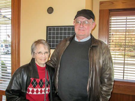
Jane and John
We reached the city park in Troy at 12:30 and were met by Jane, a friend from college, and her husband John. We enjoyed a relaxing lunch together at Bob Evans. Then they drove us by their house so we could see where they lived, before dropping us back on the trail at 2:40.
Still on the GMRRT, we walked on levees, through industrial areas and residential neighborhoods, through a complex of county government buildings, and past ball fields before reaching our destination of Twin Arch Reserve an hour and a half later. It was a great day, not slowed down by any old or new pains, and complemented by time spent with friends.
The day before, we had wasted a lot of time looking for an interesting ice cream shop before ending up at DQ in Tipp City. Since we had to go back to Tipp City this day to get the other car, and it was already 4:30, we went straight to DQ again. This time I got a Turtle Pecan Cluster Blizzard. Yes, I love blizzards—as long as they’re in a cup and not outside.
Day 11: Twin Arch Reserve to Lockington (11.3 trail miles)
This was an exciting day because we would be finishing the northern end of our hike. We had some trouble finding the ending point in the morning. The GPS wanted us to turn where there were no roads, but we finally made it to the small community of Lockington and left a car.
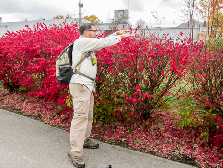
CW warming his hands over a burning bush
It was cloudy and nippy. The temperature didn’t get out of the 50s all day. When we got to Twin Arch Reserve, CW realized he’d left his jacket in the other car. He just had a long-sleeved shirt and gloves. We usually warm up pretty quickly when we hike, so he wasn’t concerned enough to drive back for the other layer. We began hiking at 9:45. The morning was spent on the GMRRT. The trail went through a wooded area on a former towpath, passed the nuclear power plant that was in operation in the 1960s, then crossed the Great Miami River and paralleled it into Piqua.
It was 11:30 when we got to downtown Piqua. We had walked close to five miles and were ready to eat, so we headed straight to the Lighthouse Café that was not far off the trail. We had discovered it during CW’s first time around the Buckeye Trail. It’s a busy and homey place with good food and friendly service. It appears to be a regular destination for a lot of old-timers. We felt right at home.
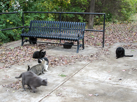
The cats we were able to wrangle into one photo
An hour later we were back hiking. The BT left the GMRRT in downtown Piqua to follow the Linear Trail. We had gone less than a half mile when we were flabbergasted to see a half dozen cats lounging on one side of the trail. Our attention was then drawn to cats on the other side. Then one emerged from the bushes. We counted ten in all. They appeared to be well fed and healthy. When we tried to approach them, most of them got up and moved away, so we couldn’t get them all together for a photo. However, a couple of them were friendly, and one even began following CW down the trail. It was hard for these two cat lovers who are presently catless to walk away, but we did.
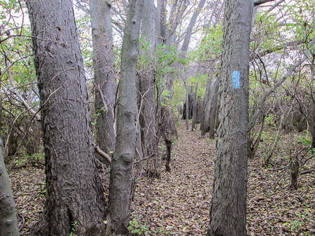
A view through the hedgerow
We continued on through a wooded area, past ponds and parks, and past a huge cemetery, all clean-looking and bright with fall color. We finally left the paved trail for a quarter mile on a footpath, then covered a half mile on a country road passing the historic Johnston Farm before turning off onto a grassy service road.
After a short distance, the BT jogged into a hedgerow that paralleled the service road. I’ve never walked through a hedgerow. It was so cool! The path was extremely narrow and flanked by tall trees planted close together. We continued on a wooded path for more than a mile. Along the trail, remnants of locks of the former Miami-Erie Canal can be seen.
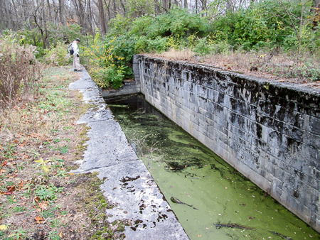
Remains of Lock 8 on the former Miami-Erie Canal
I was slowed down quite a bit because I was in my sandals. We had to watch out for rocks, tree roots, and uneven ground under the leaves. Oh, and tree thorns. When they fall to the ground, they are like jacks—there’s always a point sticking up. And one of them got me in the heel. CW went ahead after that and tried to find them before I did. Despite the difficulty in walking, it was beautiful, especially the section that was vibrant with pink burning bushes.

Surrounded by pink burning bushes
We finally made it out of the woods and onto some busy country roads that took us into Lockington. We got to the car at 3:45. That wouldn’t have been so bad except that we still had to pick up the other car and get home to Kentucky for our Bible study that night.
Ever since Day 3, we had been staying in Xenia while hiking, and leaving one of our cars in Xenia when we came home. Now we needed to take them both home. And because I hate to drive on 75 (CW’s not fond of it, either), we took back roads, making an even longer trip. When CW stopped at Tim Horton’s for his coffee, he picked up a mocha frappe for me. That was my ice cream for the day, and it kept me awake on the drive home.
Day 12: Peters Cartridge Company to Stubbs Mills Road (4.6 trail miles)
Since October was over, we called to see if the trail in front of Peters Cartridge Company was reopened. It was. On Sunday afternoon we drove one car to Stubbs Mills Road where we had skipped ahead to on Day 2. We began hiking back to Peters (counterclockwise) at 1:30 to where we had encountered the closed gate.
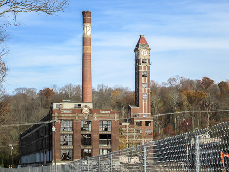
Peters Cartridge Company facility is on the National Register of Historic Places
It was another beautiful day on the Little Miami Scenic Trail, as indicated by all the cyclists and walkers we saw. The temperature was perfect in the 60s. The trees were past their peak and becoming bare, but the crisp leaves on the ground still gave me a thrill. CW and I both love the fall.
We reached Peters at 3:00, then retraced our steps (clockwise) to our car, making it a nine-mile day. Our pace was dragging on the return trip, but we had the excitement of the Bengals-Steelers game on the radio to take our minds off of how tired we were. We didn’t get back to our car until 4:50. In the long run, the extra foot miles were worth it to us to not have to shuttle cars.
We made a stop at UDF where I got one dip of Coffee Toffee and one of Caramel Chocolate Pretzel Crunch. We now had only one more hike to complete our goal.
Day 13: Eden Park to Milford (12.6 trail miles)
Originally, CW was going to extend north of Lockington for his 150 miles and save the “tail” of the BT for the very end of his second circuit hike. Our plans have been fluid, though, and he decided to stop at Lockington and do the tail now. That would provide his 150 miles, and it covers exactly three complete sections of the BT: Loveland, Caesar Creek, and Troy. So our last day of hiking would be the closest to home.
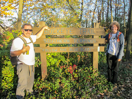
Ready to start the last day at the southern terminus of the BT in Eden Park
We began at the southern terminus of the BT, the Northeast Overlook in Eden Park. It’s only about six miles from our house. Our friend Dolores would meet us in Milford and shuttle us back. The day was sunny and in the 70s by the afternoon. It was the warmest day we had hiked, but I wasn’t about to complain about a little heat in early November.
After leaving the park, the next six miles were on sidewalks that meandered through business districts and residential areas. While on vacation, we like walking around cities, so it was enjoyable seeing the neighborhoods of
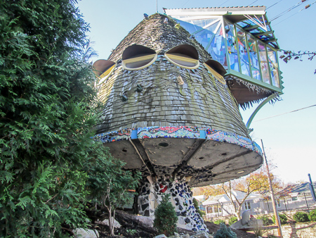
Mushroom house in Hyde Park
O’Bryonville, Hyde Park, and others close up. We passed schools, green parks, impressive stone church buildings, and mansions that sat far back from the road, partially hidden behind forested lawns.
It took us close to three hours to cover the first six miles, and that wasn’t even halfway. When we turned onto Murray Road Bike Trail, fatigue was setting in, mental more than physical. I just wanted to be finished. After less than a mile, the bike trail ended and we were back on sidewalks for two more miles, most of it along Route 50 that took us through Mariemont. The last three and a half miles were on the Little Miami Scenic Trail (LMST). CW says that stretch is a black hole. It seems to go on forever. By this time he had run out of adrenaline. We both just wanted to be finished.

Dolores celebrating our accomplishment
We rested briefly in Avoca Park, a LMST trailhead in the village of Terrace Park. Other than this green space, the trail was very much a wooded corridor that obscured our view of Route 50 on our left and an occasional building on our right. Sometimes we got a glimpse of the Little Miami River through the trees.
We couldn’t tell how close we were to the Milford trailhead, so I didn’t call Dolores in time for her to beat us there. She had planned to be standing at the finish line to welcome us with great fanfare. We finished at 2:00
Still standing at the end of 150 miles
and she arrived shortly after. We went to Panera Bread for lunch. She had been reading my blogs, so afterward she treated us at UDF where I got Fudge Nut Sundae ice cream. A true friend knows what’s important.
When Dolores returned us to Eden Park, we were exhausted. I don’t think we could have done another day. Maybe that is how it is supposed to be when we come to the end of something big. We are given just what we need to finish. In spite of our weariness, we were refreshed from the time spent with our friend and from accomplishing what we set out to do.
~~~
Over the thirteen days, we walked 152.9 trail miles plus a few more for retraced steps and missed turns. We put 1,890 miles on our cars. My pedometer logged 389,024 steps. We were blessed with unbelievable weather for October. There wasn’t one day that we didn’t say to each other how perfect the conditions were.
CW now has two 10-percenters completed, and I did more walking than I ever expected to do. I don’t know yet if it improved my cholesterol, but CW and I found out that we can survive long-distance hiking together, and even enjoy it. He’s even talking about me doing another one with him, but I’ll have to think real hard about that and talk it over with my feet. Of course, there are a lot more flavors of ice cream I haven’t tried yet . . .

Wishing everyone a fabulous fall!


Brenda
November 7, 2015Yay, you made it!! Congratulations, I’m quite proud of you both. What an accomplishment, and one I’m happy to live vicariously. 🙂 I’ve loved hearing the details. Hope your hip is fine now.
CW Spencer
November 7, 2015We are happy to provide you with some vicarious living! My hip is fine. It’s strange how pains suddenly show up, then move on to another part of the body. I guess I should be happy they are transient. Did the umbrella remind you of anybody?
Brenda
November 7, 2015I loved your red umbrella and the picture of you dancing in the rain! We are kindred spirits. 🙂