by guest blogger Bonnie Spencer
March 29, 2017
CW and I scheduled our spring 10-percenter hike to be completed by Buckeye TrailFest at the end of April. That put our first week of hiking back into March. We will do three sections of the Buckeye Trail in northeast Ohio—the points of the BT farthest from our home.
Our hike will start from the point where we ended last fall, where three sections come together. For those not familiar with the BT configuration, this is possible on the circular trail because a little loop was added to the large loop. Of course “little” is relative. It is definitely little compared to the entire BT, but it can seem varying degrees of big when you have to hike nearly 200 extra miles. From this point, the Medina section extends west, the Akron section goes south, and the Bedford section takes you northeast to Lake Erie and forms part of the little loop.

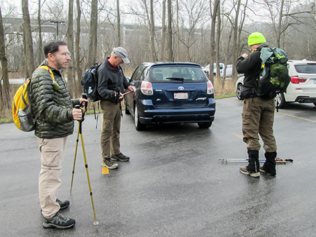
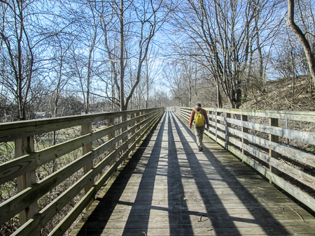
Richard, George, CW, and Bonnie ready to begin hiking on Day 1
We are blessed this time that two of CW’s hiking buddies are hiking the first two weeks with us. George will finish the entire BT just a few days after his hikes with us. Richard is working on his second time around. Because they are hiking with us, CW and I only have to drive one car. This is a great luxury and one I benefit from the most since I can just be a passenger. Hiking the BT is on my bucket list, not driving.
Day 1 (Monday): Brecksville Reservation to Boston (10.4 trail miles)
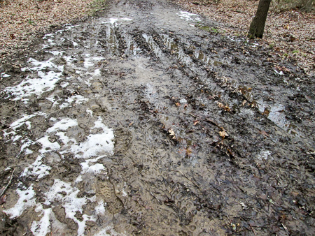
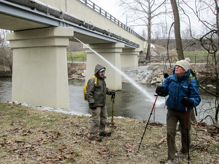
Reports of snow and mud were not exaggerated
We dropped Sugar off at the vet for the week and got promises of lots of cuddles for her. Then we headed north under gray skies and heavy rain. Because of the forecast, we figured we would be hiking in rain in the afternoon. Also, Richard had gone up the night before and reported back that there was still some snow on the ground and lots of mud.
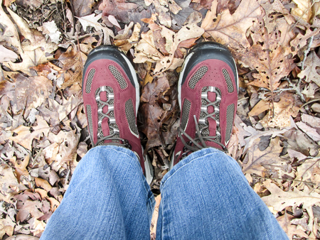
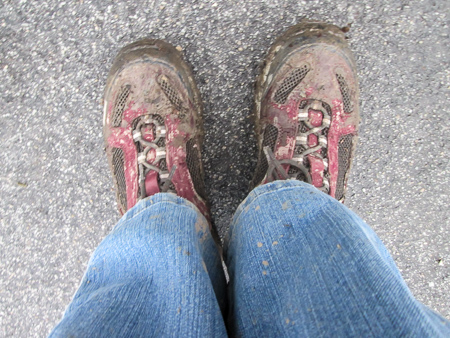
My new, beautiful, and CLEAN hiking boots
CW and I were both prepared with new hiking boots, purchased at RRT in Milford at a recent 50% off sale. The first pair I tried on was ugly. It would have taken any joy out of hiking for me to have to put those things on my feet. Then I found a pair that was red mahogany and black olive. That translates to wine, which is my favorite color. They were beautiful. My heart could sing when I wore them. I hoped to keep them looking beautiful. Oh yeah, they felt good on my feet, too.
We met George and Richard at noon in Brecksville Reservation to begin hiking south on the Akron section. Since they had already placed a car at the end of the day’s hike, we were able to start out immediately.

Hard to find a way around the muddy trail
The afternoon was gray and cool, but comfortable for hiking. The ground was dark brown and wet. It took only a few steps before hope of keeping my boots beautiful began to fade.
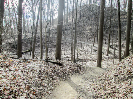
The trail we covered today is within Cuyahoga Valley National Park (CVNP). It consists of footpaths and bridle trails, so we were in mud most of the day.

One misstep could send us down the hill
It was deep in places. It was ooey-gooey. It was slippery. It reminded me of our muddy hike through Caesar Creek last spring when I damaged my ankle and toes. I walked around the mud when I could, but it looked as though previous hikers had the same idea. The bypasses were also becoming muddy. Plus, there were brambles to tangle with off the trail. In some places the trail was narrow with a drop-off so we had to be careful not to slide over the edge. It took a lot of work either way—trying to get around the mud or trying to not slide off the trail. I sounded like Brick on The Middle. If you watch that show, you are familiar with his tick of “whoop”ing. For me, it was slide—whoop! . . . slide—whoop! . . . slide—whoop!
Steps to help us up the hill
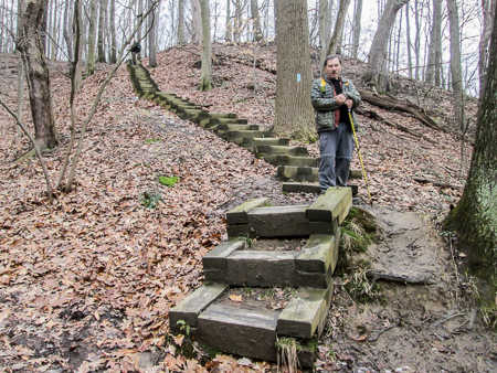
The plentiful ascents and descents were another challenge. The short trail descriptions on the BT map used some form of the word “undulate” three times for the 10 miles we were doing today. Boy, did we undulate. Sometimes the hills were so steep that long sets of wooden steps had been built into the hillside. The map said one of them had 89 steps, but I only counted 87. I was usually lagging behind trying to get my breath back.
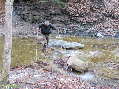
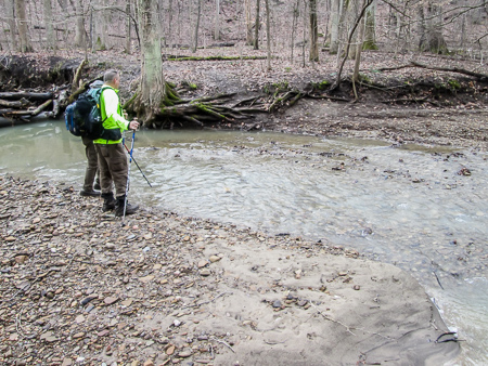
Richard carefully fording a stream
The trail went through several streams, some more tricky to navigate than others. We’d get our boots washed off a little, then step right back into the muck.
Without leaves on the trees, we could see deep into the woods. There was an open feel to it even though we were secluded. Occasionally the quietness was pleasantly interrupted by the rustling of the dried leaves still clinging to the beech trees. The papery bleached-brown leaves brightening the muddy landscape was one of the prettiest sights for me today.

Bleached-out beech leaves contrast with dark mud
After 6:30, it began sprinkling. That speeded me up and we finished at 7:00. Due to the mud and undulating terrain, it had taken us seven hours to cover 10.4 miles.
When we got back to Brecksville Reservation to pick up the other two cars, we found gates across the park roads. We kept driving around and finally went in the way CW and I had entered earlier in the day. We were relieved to see that our cars were accessible, but just beyond them another gate was closed. A park worker told us they close the gates for amphibian crossings. This time of year, in the evenings, the salamanders cross the

Park road closing for amphibian crossing
park roads to vernal pools in order to spawn. It’s important to the ecosystem that the little critters are protected from traffic.
I was tired and sore and very glad to be done with these 10 miles. My boots had been christened. Now it wouldn’t matter what came down the trail; they’d seen the worst. And they had passed their test. My feet and ankles felt perfect. I’d hardly given them a thought all day. The boots are Gore-Tex, “guaranteed to keep you dry.” Even after all the streams we had to ford, there was no water in them. In case any hikers are interested, they are Vasque Breeze 2.0 GTX.
Not so new, beautiful, and clean hiking boots
Today was a good day. No one fell down. There was no rain to speak of. It was lovely in the woods (if you didn’t look down). I learned that beech trees keep their leaves to brighten the winter forest and salamanders can close a park. After eating supper and getting checked into our motel at 9:30, CW and I were discussing where to get my ice cream for the day. At that moment, Richard appeared at our door with Vanilla Caramel Drumsticks! Worked for me. And tonight CW cleaned my boots.
Day 2 (Tuesday): Boston to Cuyahoga Falls (14.0 trail miles)
Ready to go on Day 2
Today we experienced varied weather and terrain. It was cloudy and in the 40s when we got our achy legs started on the trail at 9:00 a.m. We began on the paved Ohio and Erie Canal Towpath Trail (OECTT), a pleasant switch from yesterday, but that didn’t last long. Soon we were back on bridle trails and footpaths. More mud; more slipping and “whoop”ing. More undulations; more gasping for breath. More streams; more potential wet feet.
Richard and George contemplating where to cross
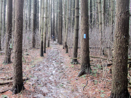
Trail through the white pines
After two miles we emerged from the woods to cross over Ohio Turnpike, then entered an area of white pines. The sun had come out and the temperature was milder. About 11:30, we left the woods again and walked into the small village of Peninsula. We were met by Richard’s cousin whom he had never met but had been communicating with.
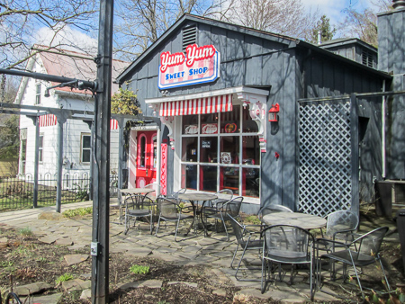
Yum Yum Sweet Shop in Peninsula
While the others walked on down the street to have lunch at a restaurant, CW and I stopped off at the Yum Yum Sweet Shop. We went straight to the cases of Pav’s ice cream. CW selected Black Raspberry Yogurt and I got Chocolate Peanut Butter Pretzel. They were both “yum yum.” It was pleasant enough to sit outside in the courtyard. We followed our dessert with food from our packs.
A text from George said their food was slow in coming so we could go ahead and they would catch up. They are both fast hikers and we often lag behind, so we jumped at the opportunity for a head start. Off we raced.
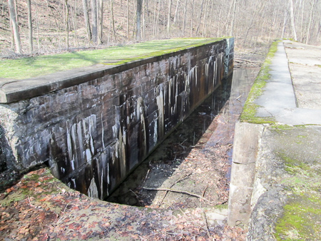
Deep Lock, the deepest on the Ohio & Erie Canal
The BT rejoined the OECTT for several miles. Here the surface was chipped limestone, 8’-10’ wide. Great for making good time. I made it my goal to reach the next point on the map, more than three miles away, before Richard and George caught up with us. I usually move faster with a goal.
The Towpath Trail passed by the preserved remains of several locks. Lock 28 is known as Deep Lock. While most locks on the canal could raise or lower a boat about nine feet, Deep Lock’s 17-foot lift was the highest on the Ohio & Erie Canal. Another lock was nicknamed Johnnycake Lock when flooding in 1828 caused the canal to fill with silt and several boats were stranded. All the passengers and crew had to eat were corn meal pancakes, which they called “johnnycakes.”

Turtles soaking up the sun in the canal
We leapfrogged along the way with a lady pushing her sleeping daughter in a stroller. Our paces were similar. She’d stop for something and we’d pass her. Then we’d take a mini break and she’d pass us.
After about an hour and a half, we reached the next point. I had accomplished my goal. We could see the guys in the distance, and they were gaining on us. We continued on.
They finally caught up with us as we stopped to take pictures of several dozen turtles all lined up on logs in the canal. We watched as another turtle tried to climb up on the end of a log that was high and slippery. It took him several tries, but he finally took his place with the others.

Beaver lodge
Beaver marsh with viewing platform
The leapfrog-lady and her daughter stopped to watch. A man wheeled by on his bicycle, then came back to take pictures. A man walking by joined us. The turtles drew quite an audience but they all faced the other way and probably didn’t even notice us.
A little farther, we crossed over an active beaver marsh on wooden walkways. No residents were spotted but there was a nice lodge to view. The area was once an automobile salvage yard, but the beavers built a dam just south and impounded water from the canal. They certainly beautified the neighborhood.
After passing another lock, we left the towpath for about three miles of meandering footpaths. The trail started out on a steep incline, but at least it wasn’t as muddy as some of the earlier trails. We joined the Deer

No blazes in O’Neill Woods but just followed the mud
Trail in O’Neill Woods. Then the trail took us onto a busy road that led into Cuyahoga Falls. After half a mile we reached the next point on the map.
We had parked a little past our last point at a trailhead, so we had .2 more miles to go to the car. We fought our way through brambly, unmaintained trail and were glad to have it behind us. Tomorrow the trail will start off on the towpath. We had covered 14 miles in 8.5 hours (counting lunch and other breaks). Slightly better mileage than yesterday.

Entering Cuyahoga Falls
Today was a good day. Again no one fell. We didn’t have a steady diet of mud. The weather was comfortable. We got to share a turtle gathering with fellow towpath travelers. I learned that beavers are pretty crafty.
Day 3 (Wednesday): Cuyahoga Falls to Barberton (16.3 trail miles + 0.5 detour miles)
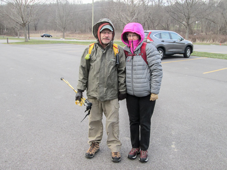
Bundled up for a day of freezing temperatures
The temperature today began in the 20s and was not supposed to get above the low 30s. The “real feel” temps were to remain in the 20s all day. We left the motel amid blustery snow flurries. I was not looking forward to a day that would literally be freezing. That’s why I don’t hike in the winter. But we all layered up and began hiking a few minutes before 9:00 a.m.
Treated water from Akron Composting Plant being released into Cuyahoga River
Today would be a longer-mileage day but the trail would have flatter terrain in general. We began on the OECTT that took us past the Akron Composting Plant where biosolids from human wastewater are converted into compost. The wastewater is then disinfected with bleach. After chemicals are added to neutralize the bleach, the water is released into the Cuyahoga River.

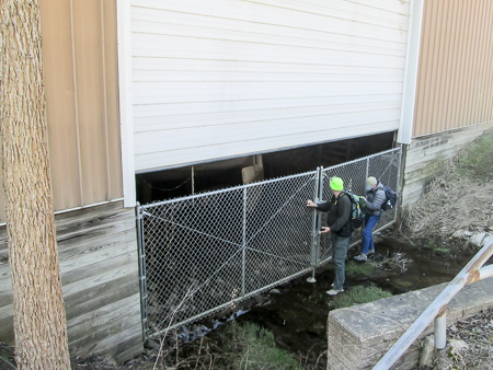
Leaving the Towpath Trail through a concrete culvert
After 1.5 miles, we left the towpath through a square concrete culvert for a footpath into Sand Run Metropark. There was some mud, but it was partly frozen from the low overnight temps making it much easier for us to navigate. The sun was out at times actually making it pleasant. The worst part for me was the cold breeze, but my earmuffs took care of that.
Meandering and undulating trail
The undulations continued today—and we met the mother of undulations. I was crawling (not literally, but close). I didn’t get a photo. It’s hard to think about taking a picture when you can’t breathe. George got to the top, looked around, then got his phone out to check the GPS. This was one of those times it was good to be slower. He started back down, saying we weren’t in the right place. I held my position for a bit to make sure he wasn’t going to come back up. Turns out we had missed a sign a while back. It probably added at least a half hour.
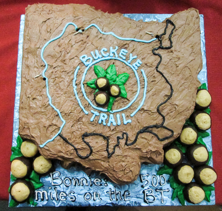
500 miles completed and shown in blue
Back on track, we joined the Parcourse Trail. I didn’t notice any of us taking advantage of the extra opportunities for exercise.
In less than a mile, we returned to the OECTT and passed the confluence of the Cuyahoga River and the Little Cuyahoga River. Somewhere in that area I hit my 500th mile on the BT. CW had misjudged how far I was last fall. He had a beautiful cake made for me for my birthday in October that showed how far I had hiked, so we had already celebrated 500 miles.

View of Ohio Canal Interceptor Tunnel construction from Hickory Street detour overlook
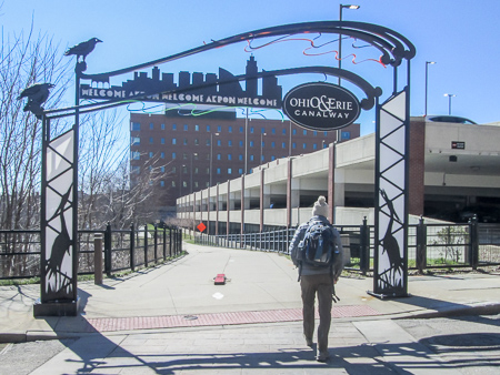
Going into Akron, we had to detour to the west of the OECTT on neighborhood streets, but we were aware of it from a trail alert on the BT website and it was well marked. The detour goes around construction of the Ohio Canal Interceptor Tunnel. The tunnel will be 27’ in diameter and will be over 6,000’ long. It will be able to hold 25.6 million gallons of stormwater and sewage during heavy rain events. The project is so enormous that the detour may exist for another couple of years.
Downtown Akron
We passed Lock 2 Park and the stadium for the Akron Rubber Ducks. A mile later, the OECTT followed sidewalks through downtown Akron. We encountered another detour but it basically paralleled the towpath and took us right past a Subway where we stopped for lunch.
After lunch, we rejoined the OECTT. There are nice parks all along the canal in Akron. A bit farther, we walked along the eastern side of Summit Lake, a lake formed naturally from glaciers. The lake’s name refers to it being the highest point along the Ohio & Erie Canal.
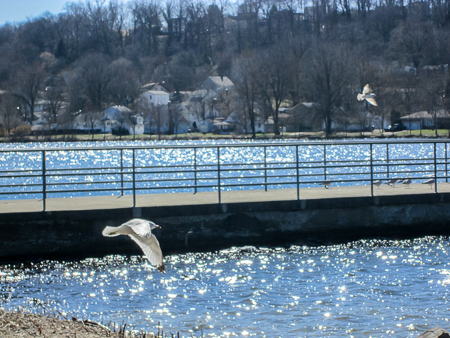
Seagulls at Summit Lake
The trail actually crosses a part of the lake on a 1,400’-long floating bridge. I couldn’t feel any movement, though. The floating towpath that existed there long ago sank as the mules moved along it. We kept high and dry.
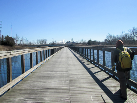
Floating bridge over Summit Lake
After three more peaceful miles along the canal, we reached our car in Barberton at 5:30 p.m. We had walked 16.3 planned miles, another half mile due to detours, and maybe another half mile from making a wrong turn. It took us 8.5 hours, the same length of time it took yesterday to do three miles less. What a difference the towpath makes.
After pizza at CiCi’s, CW and I picked up a small container of Dove Unconditional Chocolate ice cream at Sheetz gas station to eat back in our room.
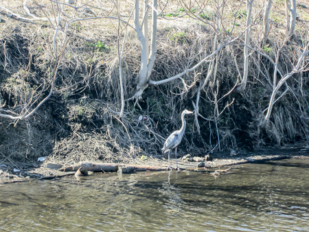
Blue heron pretending to be a tree on the canal bank
Today was a good day. The sun came out and we didn’t freeze as I had expected to. We had considerably less mud and more towpath. I saw seagulls, which always brings me joy. I saw a blue heron and got his picture before he flew away. We found CiCi’s, our favorite pizza place. I learned that Subway has good soup.
Day 4 (Thursday): Barberton to Crystal Springs (16.9 trail miles)

OECTT sign in Barberton
Today would be our longest mileage this week, but the entire distance would be on the OECTT. We all wanted to finish the Akron section and not have to hike tomorrow.
We had been consistent in our start time. Once again we began hiking at 9:00 a.m. It was below freezing when we started. The sun was shining brightly upon us, though. By the end of our hike, it would reach 50 degrees.
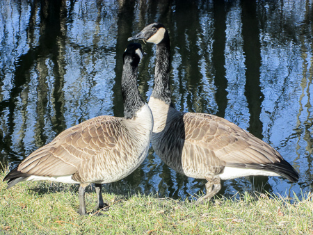
Pair of geese enjoying breakfast together
We had seen lots of geese along the canal in the past days. If they are on the bank when we pass, they always saunter down into the water. This morning a pair was too interested in breakfast and just continued eating.
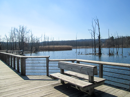
I like wooden bridges—short ones deep in the woods to get over a mushy spot or longer ones traversing rivers.
Interesting shadows on 580′-long boardwalk
Today we crossed the Tuscarawas River on a 500’-long trail bridge. In less than a mile, we were on a boardwalk about 580’ long that wound around a levee that contains one of the lime lakes.
The lime lakes are six ponds covering more than 600 acres that were filled with waste products, mostly lime and water slurry, from the production of soda ash used in making glass. When they were drained, lime deposits up to 50 feet deep remained. No plant life could grow. In the early 1980s, PPG Industries began reclaiming this land by adding nutrient-rich biosolids from wastewater treatment plants to the lime so that the land could return to nature.
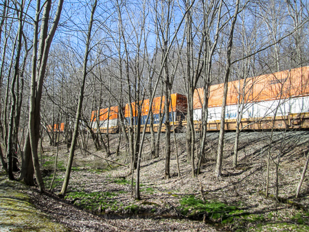
Double stacked railroad cars
For a while we walked just a few feet east of the Chessie Railroad. Two long trains streamed by us. One of them had many stacked cars, which I’d never seen. No doubt it’s common, but I don’t see many trains.
We weren’t moving as fast as the trains, but we were making good time. The Towpath Trail alternated between asphalt and chipped limestone, both better than mud.
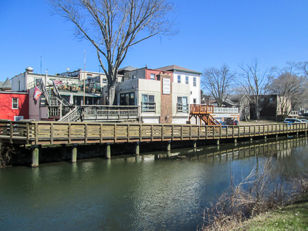
Sisters Century House Restaurant on the canal in Canal Fulton
By 1:30 we reached the village of Canal Fulton and looked for a place to eat. We discovered Sisters Century House Restaurant right on the canal. It had a comfortable feel, good food, and a great waitress. We enjoyed the lunch specials and lingered for an hour. CW and I had spotted an ice cream shop as soon as we entered the town, but with a third of our hike still before us we decided to wait for our daily treat.
Richard and George getting a peek at the St. Helena III in dry dock
On the way out of town, we passed the McLaughlin Dry Dock where the St. Helena III is stored for the winter. In season, this horse-drawn canal boat replica gives two-mile round-trip rides on the Ohio & Erie Canal. A mile farther down the towpath was Lock 4 Park with a fully-intact lock and a replica of a lock tender’s house.
Nearly 10 miles of the canal between Canal Fulton and Massillon were restored in the 1930s. It was part of a project to establish a new state park. The park never materialized, though, due to the outbreak of World War II.

George, Bonnie, CW, and Richard after completing 58.1 BT miles this week
We reached Crystal Springs by 4:30. It took us 7.5 hours, counting an hour for lunch, to hike nearly 17 miles. Not bad at all. Richard left for home. After we took George to his car, he headed home as well. CW and I stayed another night so we could rest up. We couldn’t get back in time to pick Sugar up today anyway.
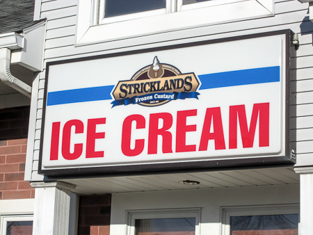
We did make a beeline to an ice cream shop down the road from our motel, though. Stricklands Frozen Custard advertises ice cream. We both got hot fudge sundaes with maple ice cream topped with whipped cream and pecans. They were delicious, but we were unsure as to whether we were eating ice cream or frozen custard. We asked. We were told custard differs from ice cream because it’s made with powdered egg. They don’t use egg, so we were eating ice cream. However, since Stricklands Frozen Custard actually did make custard when it began in 1936, they are grandfathered in and can use the name.
Is it ice cream or frozen custard?
This has been a good week. Everyone passed their endurance test of boot-grabbing mud, heart-challenging hills, and some long-mileage days. Our rain ponchos never had to come out of our packs. We couldn’t be happier with our new boots. I didn’t have to drive! We hiked 58.1 miles in four days and completed the Akron section. And I learned that sometimes it’s good to not know what’s coming!
neat cake! I think the same person wrote the map for this section as for East Fork. In fact the title of chapter 1 in North Country Quest is “Meanders and Undulations.” And… I did the O’Neill woods loop twice myself. Interesting blazing there.
The cake tasted as good as it looked. I’ll give the place a plug. It was made at Mama C’s Buttercream & Sprinkles in Bellevue, KY.
Yeah, I liked the wooden signs on posts in O’Neill Woods where blazing is not permitted.
I had forgotten about your chapter title. Catchy, isn’t it?
Wow, I can’t say I envy you but I’m impressed! Way to go!
And I’m crazy enough to be getting ready to go back for more. Ha!