
by guest blogger Bonnie Spencer
October 9, 2016
I had no intention of playing on the title of CW’s book. But as I contemplated how this 10-percenter would be different from the other two CW and I have done, I realized this would be the first one without Dad. We lost my sweet 94-year-old father in May. The thought of hiking without Dad sadly wandered into my mind and wouldn’t leave.
Of course, Dad didn’t actually hike with us, but he was there in so many ways. Before we left on a trip, he would spread out his maps to see where we were going and offer his opinion on the best route to take. He helped shuttle us on the hikes nearest his house. On the others, I’d call him with daily updates on how many miles we covered, how much cold rain or hot sun beat down on us, and what physical ailments had popped up. He was always interested in hearing the details of our adventures and viewing our photos when we returned. That would all be missing on this hike.
Although we wouldn’t have Dad back home, we would have his dog Sugar whom CW and I adopted. She figures into our hike because we had to find somewhere for her to stay in order for us to be able to go—and that wasn’t an easy task.
A month before the hike, all three of us checked out a nearby kennel. A couple weeks later we took Sugar to their Doggie Day Care to try out the place. She survived, so we made her reservation. A week later—three days before our hike—she came down with a terrible cough. We made an appointment with her vet, started her on antibiotics, and canceled the kennel reservation. Even though Sugar’s vet doesn’t board dogs, she graciously agreed to take her for the week. She had a soft spot for Dad.
This was a great test for what would become my goal and motto for this hike: Enjoy the moment. Regardless of what didn’t go as planned—and there were at least 7,200 chances for that (5 days = 7,200 minutes)—I wanted to accept, adapt, and flow with a minimum of grumbling. Tall order, I know.
Day 1: Waterville to Fuller Preserve (8.5 trail miles)
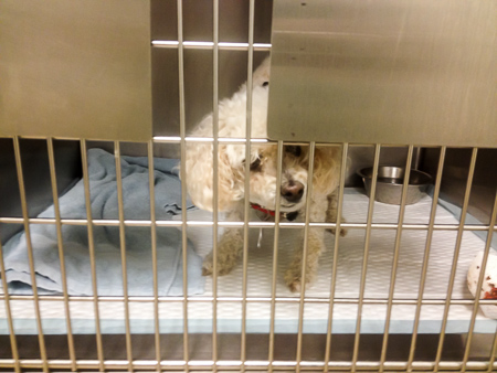
Sugar behind bars
We were getting a head start on our “October” hike by starting the last week of September. At 9:15 am, two days after the call to the vet, we had Sugar at her doctor’s appointment. Forty-five minutes later, we left her trembling and crying and coughing in an isolation cage. We drove on out of town in our two cars, headed for northwest Ohio to continue our hike from where we’d left off in the spring.
As usual, we took back roads with me following CW. When CW thought we were close to the area we would be hiking, he disregarded the GPS and took an unexpected turn on a road going east to get to SR 25, hoping to cut off some time. He’s done that before. Sometimes it works. Not so much this time. I couldn’t find the road anywhere on the Buckeye Trail map, and we drove around quite a while on various roads heading east and north, hitting dead ends and backtracking, before we were able to connect with SR 25. We finally realized we had turned east way south of the area on our map. I hoped our hiking would go more smoothly.
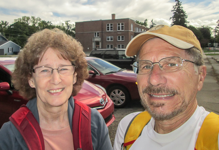
Starting our 10-percenter in Waterville
By then it was 2:00, so we stopped for lunch in Bowling Green before driving on to Fuller Preserve, our ending spot for the day. We left a car and drove to Waterville. It was nearly 3:30 when we began hiking.
The last time we were in Waterville, we were soaked to the bone. I thought we might have a repeat when we drove through heavy rain earlier in the day. However, by the time we began hiking, we were pleased to be under sunny skies.
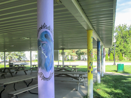
Painted shelter posts at Lusher Park in Haskins
After crossing the Maumee River, we had to walk on SR 64 for two miles. No fun at all! It was a very busy road with a narrow shoulder and grass beyond. Having no fondness for chiggers, I try to avoid grass. CW recently had a couple bad cases of chiggers and I didn’t want to share his misery. But I decided chiggers were better than splats, so I kept hopping into the grass. It was a relief to walk on sidewalks through the village of Haskins.
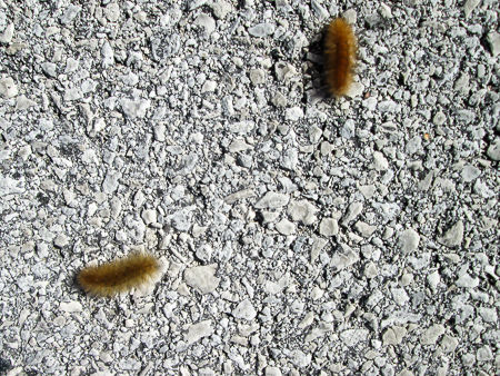
In search of a winter hideout
The rest of the way we walked on quiet country roads, including the Road of the Golden Caterpillars. Well, that wasn’t the name on the road sign, but we saw an abundance of caterpillars crossing the road. A great many were golden, but there were also a lot of the well-known black and brown wooly worms. They were, no doubt, searching for overwintering sites. Unfortunately, we also saw some splatterpillars since they don’t have the ability I do of hopping into the grass.
We passed many cornfields, some already bare. Those waiting to be harvested sang their rustling songs with the help of a strong breeze, harmonizing with the crickets they sheltered. It was a perfectly-tuned performance. At 6:40 we reached Fuller Preserve, which was just a small pull-off on the side of the road with two trails leading into a five-acre woodlot.
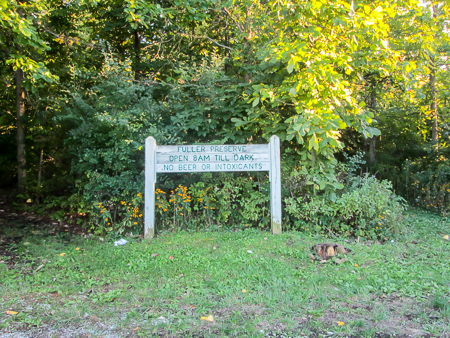
Fuller Preserve
We had only walked 8.5 miles, but we knew this would be a short-mileage day due to our arrival time. Our GPS led us in search of ice cream, first unsuccessfully to Nellie’s something-or-other that was no longer there, then to Sweet Retreat in Waterville. It was there and we both got Shamrock Sundaes. They were OK, but we would have preferred less mint and lots more hot fudge.
By that time, it was dark and we had an hour’s drive in unfamiliar territory on some busy roads to get to our motel in Fremont. It was a bit harrowing and made me work extra hard at enjoying the moment, but we arrived safely at 9:00. Over the next days, we would be hiking in that direction and not have as far to drive at the end of each day. And we decided we would do whatever we could to reach the motel by dark.
Day 2: Fuller Preserve to Pemberville (15.2 trail miles)
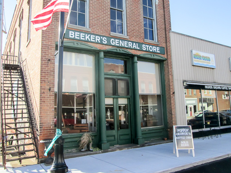
Beeker’s General Store in Pemberville
We drove to Pemberville and parked in the public parking lot behind Beeker’s General Store, taking a few minutes to walk through the store. It was long and narrow and packed with all kinds of old-fashioned stuff. If I hadn’t been so eager to get on the trail, I would have spent more time there.
We drove the other car on to Fuller Preserve and began hiking at 10:00. It was sunny, cool (60s), and windy. The trail today took us on country roads past corn, soybean, and cabbage fields. For the most part, we enjoyed the quiet and safety of little traffic.
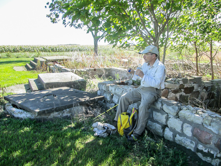
A shady spot for lunch
For two hours we walked in the sun with no place to rest. We finally spotted the remains of a house foundation that were well-shaded by trees and chose to eat our lunch there. The combination of shade and wind chilled us, and after 20 minutes it felt good to get back in the sun.
More than a dozen cows were lying in a field close to a fence. As we approached, they all stood and lined up to watch us pass by. Farther down the road, we got the attention of a group of goats. And a lone horse grazing in the middle of his pasture stopped eating to come say hello. It must get lonely living in the country.
Keeping an eye on us
After ten miles, a lady stopped her car to ask if we needed a ride. It was tempting, but we told her we had to walk it. We met another lady at her mailbox. She immediately asked if we were hiking the Buckeye Trail. She owns property in Hocking Hills that is also on the BT. We had a nice chat.
When we reached Pemberville, the BT turned onto the Portage River Trail, a shady gravel path that led into town. After all the roads we had walked, it was nice to be in the woods, even if for only half a mile. We had another half mile on sidewalks before we reached our car at 4:20.

Ladies’ room at the Speedtrap Diner
Beeker’s advertised ice cream on the side of the building. How convenient . . . except they don’t sell it in the fall. So we drove to the Speedtrap Diner in Woodville where I got a Chocolate Fudge Cake Batter Shake (and visited their awesomely-decorated ladies’ room). It had been a long day. We were exhausted and needed to rest up for an even longer day tomorrow.
Day 3: Pemberville to Lindsey (16.2 trail miles + 2 detour miles)
The forecast for today was rain, rain, rain. We had walked through downpours last spring so I knew I could do it, but it was nothing I looked forward to. In case the day got too nasty, we had decided to break our hike into two legs.
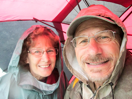
Enjoying a rainy moment
We set out at 8:50 in a steady rain. CW used his large umbrella. I donned my Frogg Toggs poncho. We had recently purchased two. The poncho worked great for my pack and most of me, but the rain wicked up my pantlegs to my knees. I figured my pants would be totally soaked by the end of the day.
I became warm under the poncho. After an hour, the rain became a sprinkle, then stopped altogether, so I was able to put my hood down and cool off. The sun tried to peek out of the clouds but couldn’t quite make it. We were glad because the overcast sky kept the temperature quite comfortable.
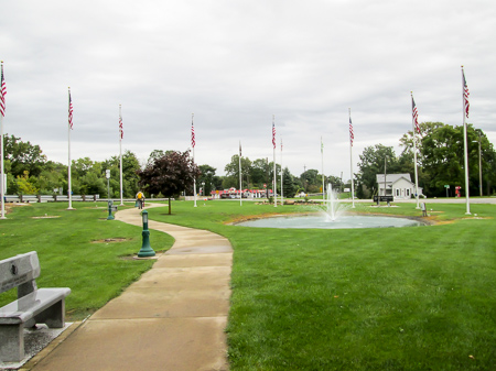
H. W. Busdiecker Park in Woodville
Six miles in, we reached Woodville. We went a few feet off the blazed trail to use the bathrooms in Trail Marker Park. They were locked, but a man across the street who worked for the city was kind enough to come over and unlock them for us. Just a bit farther, we walked through H. W. Busdiecker Park, which features 13 flags that commemorate the astronauts who gave their lives during the space program up to the mid-1990s.
We passed the Speedtrap Diner. The burgers were calling out to us but we pressed on, deciding to return later when we reshuttled the cars.
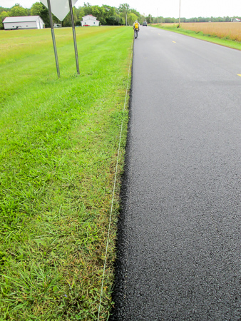
Nice edge on a newly-resurfaced road
Signs warned of a detour ahead. We had learned of it from the BT website and were prepared for it . . . mostly. The site offered two detour possibilities. The option we chose would add two extra miles to the trail but it kept us on the BT for all but .8 mile of the actual trail. Unfortunately, we added almost another mile from bad navigation (my fault) and road signs that were turned the wrong way (hard to prepare for). Thank goodness for the lady out in her yard who set us straight!
One road had been freshly resurfaced. All along the edge was a string that we figured was an aid to getting a straight edge on the road. It looked as though Dad had been there. Sixty years ago when he was growing a new hedge, he created an elaborate system of strings that he set up for each trimming. He had the squarest, sharpest hedges in the neighborhood.
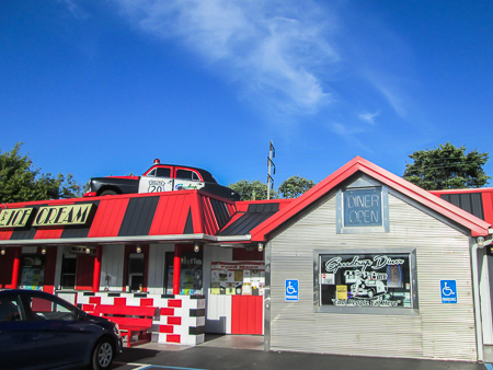
Speedtrap Diner in Woodville
We made it into Elmore and immediately drove to the Speedtrap. Our burgers were delicious! We highly recommend them. It would have been nice to stop for the day, but we had 5.5 more miles to cover. We reshuttled the cars and set out at 4:30 from Elmore.
The BT followed the North Coast Inland Trail (NCIT), a rail-trail, to Lindsey. We tried to beat the rain and dark, and we did both. We finished by 6:30. Although we began the second leg under an angry sky, there were only a few sprinkles on the way and we ended up on very good terms. It didn’t rain until we reached our other car in Elmore. So much for a rained out day.
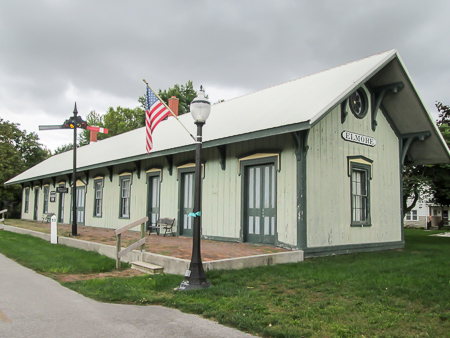
Historic train depot on the North Coast Inland Trail in Elmore
Our GPS was at it again. It led us to Toft’s Ice Cream Parlor in Fremont. When we arrived, there was an AVAILABLE sign in the window of an empty shop. What a cruel trick. We ended up at DQ where I got a Fudge Stuffed Cookie a la mode.
I doctored several blisters that night but none of them were bad enough to interfere with our plans.
Day 4: Lindsey to Old Fort (16.7 trail miles)
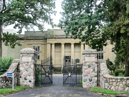
Rutherford B. Hayes Museum in Fremont
Today would be another big-mileage day. We decided to do it in two legs again. CW worked out a way of flip-flopping the legs so that we would be moving only one car in the middle. We would cover the trail from Lindsey in the north to Old Fort in the south with Fremont in the middle. Our first leg would be Fremont to Old Fort. CW got permission to park a car at Old Fort Country Market.
Back in Fremont, we began the day’s hike at 9:45 from Birchard Park. We walked the quiet neighborhood streets, passing the Rutherford B. Hayes Presidential Center. Several other walkers were enjoying the pleasant morning on the trails on the museum grounds. I learned from a sign that President Hayes’s middle name is Birchard, which answered my curiosity about the park’s name.
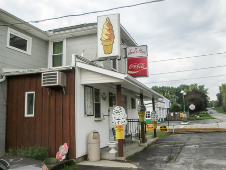
Jon-Z’s Place screams ice cream
We passed by a small restaurant, Jon-Z’s Place. I didn’t realize at the time that they served food. I saw the ice cream signs out front and checked the closing time. We would end the second leg in Fremont, so we now had the incentive to finish the hike in time to get back to Jon-Z’s before 6:00.
Before an hour had passed, we took off our jackets. Even though it was still cloudy, we were warm from walking. One road led us along the Sandusky River. We passed Lazy River Campground and saw a couple bears down by the water. They were probably looking for food because they looked as thin as plywood.
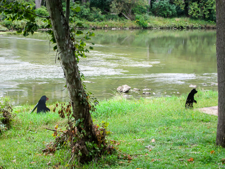
Lean-looking bears by the Sandusky River
An hour later, the trail took us over a guard rail, across a grassy field, and into Wolf Creek Park. The park is sandwiched between SR 53 and the Sandusky River. CW was not looking forward to this stretch. He remembered the trail being overgrown and not marked well. However, we found it to be well-blazed and easy to navigate. The paths varied from grass to dirt to gravel.
We followed more country roads into Old Fort and bought sandwiches at the Country Market for lunch. We like to give a little business to people who help us out. CW got permission to park there again tomorrow, and we drove up to Lindsey for our second leg.
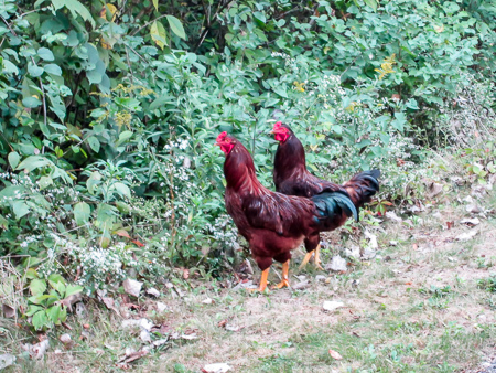
Two hikers on the NCIT before they disappeared into the woods
We were back on the NCIT. A highlight of the afternoon was hiking a short way with two roosters. Eventually the trail will connect Toledo with Cleveland and Akron and the BT may share more of it, but for now it ended when we entered Fremont.
The last 2.5 miles went through town, mostly on sidewalks. We had a little rain the last few miles. The ponchos went on and off. We reached Birchard Park at 5:00, crawled into the car, and drove straight to Jon-Z’s. I got a Butterfinger Mixer.
We had finished the Pemberville section. Whatever we could do the next day would be icing on the cake.
Day 5: Old Fort to SR 228 (7.9 trail miles)
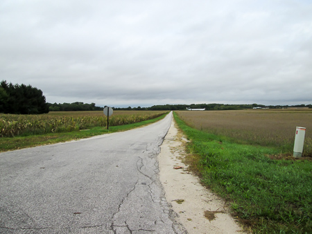
This would be a short hiking day since we had to drive home and pick up Sugar before the vet’s office closed. As we started the Norwalk section, the BT would take us entirely on country roads, the kind where it’s difficult to find a place to park.

A great parking spot along a country road
Leaving one car at Old Fort Country Market again, we drove the BT looking for a good place to park at a distance we thought we had time to cover. We located a large gravel shoulder about 8 miles out and began hiking from there back to Old Fort. We don’t like to walk counterclockwise, but in this case it seemed like the most efficient use of our time.
For over four miles, not one car passed us going in the opposite direction. It was lovely not having to scoot off the road. Once again, in spite of a rainy forecast, we were enjoying dry, sunny weather. After a half hour, our jackets came off.
Generally I carry the map in my hand, referring to it often. It seems to help the time go more quickly when I can mentally check off the points we pass. Today, though, I didn’t have the map out since we were following the blazes back the way we’d just driven. At one point I wanted to check something, but the map wasn’t in my pocket. I knew I’d had it about a mile back when we stopped to take off our jackets. We couldn’t afford the time to go back and look for it, so we continued on with me grumbling at myself. I was finding it a little difficult just then to enjoy the moment.
On a busier road we stopped to talk with a road worker who was directing traffic around a fresh patch of tar. He’s lived in the area 45 years and had never heard of the Buckeye Trail. He was intrigued. One more Buckeye now knew about the trail in his backyard.
The spot where our map jumped ship
We finished about 11:40 and drove back to the other car, looking carefully for the missing map. Sure enough, it was lying in the road where we took off our jackets. What a relief to me. We returned to the store and bought sandwiches again for lunch. I also got my ice cream there: a Choco Taco.
It was nearly 1:00 when we started for home. Driving the back roads and getting lost in Findlay for a bit, we got to the vet’s at 4:30. Sugar was ecstatic to get sprung. We left there with additional meds to finish off her cough and a list of kennel recommendations from the staff.
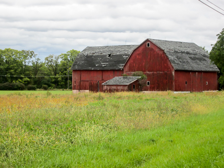
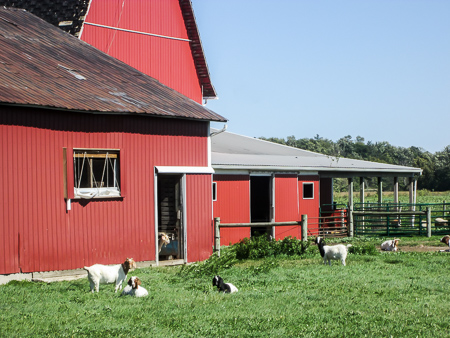
One of many beautiful barns we saw
The week had been successful. We had finished one section and begun the next, hiking a total of 66.5 miles. In spite of several wet forecasts, we had hiked in only one hour of soaking rain and maybe another hour of moderate wetness. Nothing had happened to send either of us to a doctor. Sugar was on the mend. And I had enjoyed many moments that surprised me.
We plan to take a week off, check out some kennels, and go back up the following week.


Dolores R. Birkle
October 20, 2016Went on this fun filled hike with you recently. Loved seeing Ohio with you in this way and enjoyed your comments. The special kinds of ice cream you find in these little towns is amazing. It didn’t occur to me there could be so many. CW’s short cuts (disregarded the GPS) are so funny. You get to see even more of Ohio than you planned on those days. Loved seeing your pictures. You look healthy from all that walking! “Splatterpillars” and “cornfields harmonizing with crickets – perfectly tuned” are fun word pictures for me. You seem to be a guest visiting the cows and roosters where they live – a bright spot in their day! Who ever could think that Speedtraps burgers could be delicious. Of course I am laughing. I must end for now, see you whenever that works out for you.
CW Spencer
October 20, 2016I’m glad you got some laughs from this. If we are bright spots for the cows and roosters, they must lead very boring lives. And “all that walking” isn’t helping me lose any weight. Wonder if it could be the ice cream . . .
Bonnie